Complete Guide to TerrainForge3D
Transform real-world maps into 3D printable models
Quick Start (3 Easy Steps)
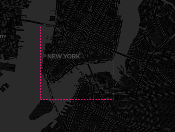
1. Select Your Area
Click once to start, move to size, click again to finish
2. Pick Features
Select which map elements to include
3. Generate & Download
Click generate and download your files
Selecting Your Map Area
Interactive Selection Methods
Click & Drag Method
- Click once on the map to set your starting corner
- Move your mouse to size the selection square
- Click again to confirm your selection
- Use "Restart Selection" to try again
- Regular users: Maximum 10×10 miles
- Smaller areas = faster processing & better detail
Coordinate Methods
- Center Map: Enter latitude/longitude to jump to a specific location
- Paste Bounding Box: Copy coordinates from bboxfinder.com or similar tools
- Copy Selection: Save your current selection coordinates for later use
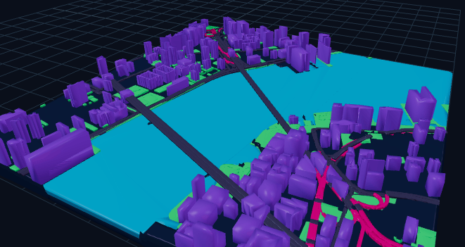
Layer Options Explained
Basic Layers
Buildings
Includes all building footprints from OpenStreetMap:
- Residential homes and apartments
- Commercial and office buildings
- Industrial structures
- Public buildings (schools, hospitals, etc.)
Water
Natural and artificial water features:
- Rivers and streams
- Lakes and ponds
- Coastlines and beaches
- Canals and reservoirs
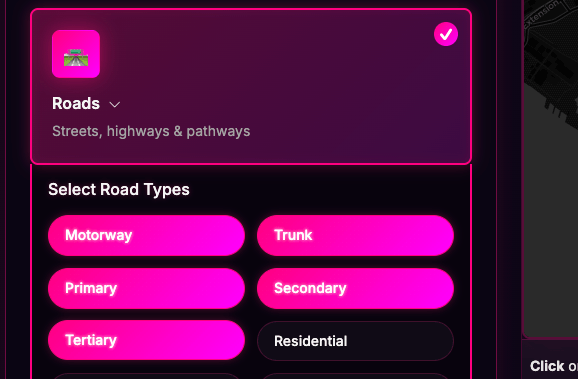
Roads - Advanced Type Filtering
Fine-tune which road types to include in your map:
Major Roads
- Motorway: Highways/freeways
- Trunk: Major arterial roads
- Primary: Main city roads
- Secondary: District connectors
Local Roads
- Tertiary: Local connectors
- Residential: Neighborhood streets
- Service: Parking/access roads
- Alleys: Narrow passages
Special Types
- Footways: Sidewalks & pedestrian
- Park Paths: Trails & cycleways
- Tunnels: Underground passages
- Bridges: Elevated crossings
Special Features
Railways
All rail infrastructure including tracks, stations, and yards
Ski Trail Mode
Replaces roads/buildings with ski pistes and trails for winter sports maps
Elevation Contours
Topographic lines from satellite data (1-20 contour lines)
Export Formats
3MF - The Future of 3D Printing
What is 3MF?
3MF (3D Manufacturing Format) is a modern file format designed specifically for 3D printing. Unlike older formats, 3MF preserves:
- Multiple Materials: Each feature (roads, buildings, water) can be assigned different materials
- Color Information: Full color support for printers that support it
- Mesh Integrity: Guaranteed watertight meshes for reliable printing
- Metadata: Print settings and material recommendations
Supported Printers:
- Prusa (MK3S+, MK4, Mini, XL)
- Bambu Lab (X1, P1P, A1)
- Ultimaker Series
- Any modern slicer (PrusaSlicer, Bambu Studio, Cura)
Material Recommendations:
- Base/Ground: Dark PLA or PETG
- Buildings: Gray or white PLA
- Roads: Black or dark gray PLA
- Water: Blue transparent PETG
- Parks: Green PLA
- Visual road hierarchy with filled polygons
- Multi-pass support for engraving depth
- Automatic bridge preservation
- Smart intersection merging
Customization Options
Visual Settings
Map Dimensions
- Map Size: 1-20 inches square output
Frame Options
Add a raised frame around your 3D printed map:
- Enable/disable frame checkbox
- Adjustable width: 5-100mm
- 2mm rounded corners for smooth edges
Advanced Geometry Settings
| Setting | Range | Purpose | Recommendation |
|---|---|---|---|
| Simplify Tolerance | 0.1-10m | Controls detail vs. smoothness | 0.5-2m for most maps |
| Min Building Size | 0-2000m² | Remove small structures | 20-50m² to exclude sheds |
| Min Island Size | 0-100000m² | Fill small water holes | 1000m² for cleaner cuts |
| Min Pond Size | 0-100000m² | Remove tiny water features | 5000m² typical |
| Min Road Gap | 0-1000m | Prevent narrow gaps | 10-20m for printable roads |
Creative Use Cases
Personalized Gifts
Create custom maps of:
- Hometown memories
- Wedding venues
- First date locations
- College campuses
Home Decor
Design wall art featuring:
- Neighborhood maps
- Vacation destinations
- City skylines
- Lake properties
Professional Uses
Business applications:
- Real estate displays
- Urban planning visuals
- Tourism materials
- Educational resources
Library & Credit System
Map Library
Your personal collection of generated maps:
- Access all previously generated maps
- Re-download files anytime
- Regenerate maps without using credits
- View saved parameters for each map
- Files stored for easy access
Credit System
How Credits Work
- 1 credit = 1 map generation
- 2 free credits on signup
- Credits never expire
- Library regenerations are free
Getting More Credits
- Purchase credit packs as needed
- Upgrade to unlimited for heavy use
- Secure payment via Polar
- Instant activation
Pro Tips & Best Practices
For Best Results
Performance Tips
- Start with smaller areas (1-2 sq miles)
- Disable unused layers
- Increase simplification for large areas
- Use min size filters to reduce complexity
3D Printing Tips
- Use 3MF format for multi-material support
- Print with 0.2mm layer height for good detail
- Enable supports for bridges and overhangs
- Consider scaling up for easier printing of fine details
Common Patterns
- City Centers: Buildings + roads, no water, high detail
- Coastal Areas: Water + roads, simplified buildings
- Mountain Regions: Elevation contours + minimal roads
- Neighborhoods: All features, medium simplification
Troubleshooting
Common Issues & Solutions
- Reduce selection area size
- Disable elevation contours (most intensive)
- Increase simplification tolerance
- Turn off less important road types
- Increase all minimum size filters
- Set simplification to 2-5m
- Disable footways and park paths
- Use fewer contour lines (5-10 max)
- Check if features exist in OpenStreetMap
- Reduce minimum size filters
- Ensure correct layers are enabled
- Try a slightly larger selection area
Still Need Help?
Contact support with your map parameters and we'll help troubleshoot your specific issue.